

Geography
Nepal in a Nutshell
Nepal is a landlocked country in South Asia. Its area is 147.18 km2, its east-west extension is about 800 km, the north-south extension at its maximum is 240 km. The bordering and enclosing countries are Tibet, respectively China, in the north, and India in the south. It hosts the second largest altitude range in the world, beginning in the Terai region at less than 100 m above sea level and ending at the top of Mount Everest at 8,850 m. With this dramatic difference in elevation comes a special ecological diversity, where climate, geography, and infrastructure vary greatly in a span of only 160 km. As the Himalayan Mountains, with their 45 million years of age, are among the younger in the history of the earth, Nepal is located in a seismically very active zone. The consequences of this are that the mountains themselves are less rounded and altered by erosion, and that they grow steadily by about 1 cm per year, resulting in natural erosion, landslides, mud-laden rivers, and earthquakes. Several rivers, all of which sooner or later flow into the Ganges, created deep gorges in the landscape. The Gali Kandhaki valley between the Annapurna and Dhaulagiri massifs is considered the deepest gorge in the world, with a depth of 7 km and a length of 20 km.
Nepal can be divided into several physiographic regions: the plains in the south, the four mountain ranges and the valleys between them. Most often, however, Nepal is divided into the three areas of Terai, Pahar or midlands, and Himal or high mountains.
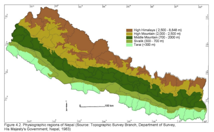
This map illustrates the major regions of Nepal: the Terai region, the Inner Terai region, the Midlands, and the Himalaya Mountains. It also shows the elevation distribution and the steady rise from south to north and west to east.
Terai
The Terai region is a flat plain that hosts several hill ranges. The Gagentic mountain range extends inland for about 40 km before the land rises 900 m to form the Chure Hills (Siwalik Hills). These extend over the entire length of the country and are one of the four mountain ranges in Nepal. This range separates the Terai region from the Inner Terai region or the Dum. The Terai occupies 14 % of the country’s land area and is home to 47 % of the population. Due to its low erosion risk, fertile soil, subtropical to tropical climate, it is the most important agricultural area of Nepal. Almost all industrial settlements, outside Kathmandu, are located in this region.
In the north of the Inner Terai region stretches the Mahabharat mountain range, also called the low mountain range. This reaches heights of up to 2,700 m and is characterized by water-retaining soils, which allow cultivation and terraced agriculture.
Pahar / Midland
Between the Mahabharat Mountains and the Himalayas is a wide, extensively cultivated belt. This is called the Midland or Pahar zone. This includes the fertile regions of Kathmandu, Banepa and Pokhara. Its area amounts to 30 % of the total land area and provides living space for another 45 % of the population. Here, mountain peaks reach heights of up to 3,000 m. Microbiology, soil and geomorphology differ in the midland within small areas, which significantly changes the conditions of settlement and agriculture from place to place. Nevertheless, it is this region from which the core settlement of Nepal originates.
Himal / High Mountains
The Himalayas or high mountains are home to eight of the ten highest peaks on earth. However, the Himalayas do not form an unbroken wall of mountain peaks; rather, groups of mountain massifs formed here. The majority of the population settled in the valleys, but in summer settlements can be found up to 5,000 m above sea level. The southern slopes are hit by heavy monsoon rains regularly, making agriculture very difficult due to soil erosion. The northern slopes, located in the rain shadow, receive almost no rain, which in turn makes agricultural cultivation almost impossible. In general, there is a food deficit in the Himalayan region and the largest source of income is tourism. The region is crisscrossed by passes, which have served as trade routes for centuries.
In the north of the Himalayas is an extremely arid region, the Trans-Himalaya, similar to the Tibetan Plateau. This plateau encloses the dry valleys of Mustang, Manang, Dolpa, as well as the Tibetan Marginal, the fourth mountain range. The Trans-Himalaya is also in the rain shadow and therefore suffers from very low rainfall.
The “real” and therefore Tibetan name of Mount Everest is Chomolangma, which can be translated as Goddess Mother of the Universe. The Nepalese Sanskrit name Sagarmartha, can be interpreted as forehead of the ocean.
The Sanskrit word Himalaya means abode (alaya) of the snow (himal). 64 % of Nepal’s land mass is mountains.
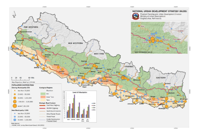
This map shows a distribution of the population of Nepal, as well as the infrastructure network and the division into the four largest regions.